In June of 2020 the killing of George Floyd sparked civilian uprising(s) calling for racial justice. Since then the pursuit of racial equity has become a central conversation for many. This conversation has increased focus on how redlining, gentrification, and the clustering of disadvantaged individuals in segregated communities impacts minorities.
According to Dr. Lawrence Brown, author of The Black Butterfly: The Harmful Politics of Race and Space in America, equity is a “process of repairing damage and making communities whole;” moreover, he states that before we can achieve equity between race(s), there must first be equity in the communities where the disadvantaged individuals reside (Brown, 2021). Dr. Brown then defines a new term, spatial equity. Spatial equity occurs “when resources and amenities are intentionally deployed based on demonstrated neighborhood needs while disamenities are removed or dismantled based on disproportionate neighborhood harms.” Moreover, spatial justice can be defined as “the fair distribution of burdens and benefits of development, and the fair distribution of resources in the city, including urban space. It includes a distributive dimension and a procedural dimension (how and by whom the distribution is decided).” (Spatial Justice Network, 2021). Dr. Brown contextualizes the long-term effects of government policies that were intended to segregate and cluster minorities by highlighting the turbulent history of Baltimore, Maryland. In addition to negative public comments perpetuating prejudices, Baltimore has a history of redlining, segregation, hyper-policing, and displacement; subsequently, its Black communities have been deprived of resources and Baltimore has been locked into a perpetual cycle of violence and protest.
The Community Services Block Grant (CSBG) and Weatherization Assistance Program’s (WAP) historic and current commitments to serving low-income communities, individuals, and families necessitates the intentional pursuit of equitable distribution of services, funding, and outreach. Both the U.S. Department of Energy (DOE) and the Administration for Children and Families (ACF) have shared information regarding their efforts to build equity in these federal programs.
In alignment with the President’s Executive Order On Advancing Racial Equity and Support for Underserved Communities Through the Federal Government, ACF has stated that racial equity is a priority in their agency and programs. The goal of CSBG is to reduce poverty through locally-driven community action. Reducing poverty in communities requires a thorough, ongoing approach to addressing community needs and a deep understanding of equity. Viewing data from a spatial equity perspective highlights areas for further investigation and outreach, all in the pursuit of reducing poverty for individuals and families.
Similar to the ACF approach to CSBG, the Justice40 Initiative was the result of an executive order by the President to advance environmental justice efforts in underserved communities. This government-wide initiative seeks to deliver 40% of the overall benefits of federal investments to disadvantaged communities, and the Weatherization Assistance Program was selected as one of the pilot programs for Weatherization assistance programs that can utilize maps and the concept of spatial equity to ensure equitable service delivery and alignment with the goals and requirements of Justice40. Recently, the White House released the Climate and Economic Justice Screening Tool to help identify underserved communities and aid in Justice40 efforts.
Mapping tools can help accurately portray the current distribution of resources and illuminate areas of opportunity to better serve communities. In particular, maps that highlight concentrations of poverty, race, housing affordability, employment opportunity, and related indicators are useful for CSBG and WAP. Turning raw data into visual insights can reveal distinct geographic divides and provide evidence for investing in targeted approaches to increase opportunity and access.
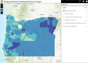
The State of Oregon’s work on mapping energy burden by race provides an excellent example of spatial equity in action. The map created by Oregon Housing & Community Services (OHCS) includes census-tract level data on energy burden by race and ethnicity as well as other indicators like energy cost index. This map was the result of one of Governor Kate Brown’s executive orders and a statewide effort that brought Oregon’s Housing Department, Public Utilities Commission (PUC), and Energy
Department together to assess energy use in affordable housing stock and develop a 10-year plan to achieve maximum efficiency. OHCS used ArcGIS (a mapping software) to create a map illustrating energy burden that enabled targeted weatherization assistance to low- and moderate-income populations. More information about the methodology and data sources is available in the article “Spotlight on energy efficiency in Oregon: Investigating dynamics between energy use and socio-demographic characteristics in spatial modeling of residential energy consumption.”
The information provided in the energy burden map enables State and weatherization subgrantees to easily provide evidence and justification for targeted outreach efforts. Since DOE and LIHEAP allow for prioritization of energy burdened groups, the State encourages subgrantees to use the data to identify populations more heavily impacted by energy burden, and this, in turn, allows for decision-making and strategic outreach efforts tailored to local communities. The map also provides data useful for policymakers and helps drive funding for this spatial equity work. As this map is updated regularly, it allows for the ongoing measurement of energy burden by race over time. OHCS convened and engages with a BIPOC-led steering committee that works to ensure that the allocation of project dollars aligns with the most energy-burdened populations.
The space in which we live has positive and negative dimensions, and the historic and ongoing effects of hyper-segregation, redlining, and gentrification result in an inequitable allocation of public goods. An understanding and continual pursuit of spatial equity helps to ensure the equitable distribution of services provided through WAP and CSBG. In addition to using maps to identify and target outreach to communities, spatial equity also includes building equity into service distribution methods and how they are created. CSBG and WAP State Offices are well-positioned to utilize maps and diverse advisory committees to build programs that strive toward equity.
Resources:
- Redlined neighborhoods: https://dsl.richmond.edu/panorama/redlining/
- Climate and Economic Justice Screening Tool: https://screeningtool.geoplatform.gov/en/cejst#3/33.47/-97.5
- Equity data tool: https://apps.urban.org/features/equity-data-tool/index.html
- National Equity Atlas: https://nationalequityatlas.org/
- Spatial justice: https://spatial-justice.org/definitions/
References:
- Brown, L. T. (2021). The Black butterfly: The harmful politics of race and space in America. Johns Hopkins University Press.
- Spatial Justice Network. (2021, May 29). Definitions. The Spatial Justice Network. https://spatial-justice.org/definitions/
Authored by Paige Milson & Khari Grant